The Challenge
Natural resource managers often face the challenge of identifying and prioritizing locations for habitat protection and restoration. Part of that challenge is understanding how climate change will alter the current condition of ecosystems, particularly in highly dynamic systems like rivers and streams. Climate change is already altering water temperature and streamflow patterns which can degrade waterbodies by decreasing water quality (e.g., dissolved oxygen concentrations, total suspended solids), increasing cyanobacterial blooms, and decreasing the ability of systems to support imperiled species, among other impacts. The societal and economic toll is reflected as river closures during heat waves, reduced fishing opportunities, and a loss in aquatic biodiversity.
This project is the first to downscale projected water temperatures at the stream/river reach level, providing context of the velocity and magnitude of climate change-related changes in the Commonwealth’s rivers and streams. Results from the project facilitate prioritization of conservation by identifying reaches that will degrade faster (at a decadal time scale) as well as those that will act as climate change refugia. Climate change refugia are those habitats that are changing at a slower pace than adjacent or similar habitats, allowing for greater adaptive capability of the organisms found within them. Results from this project will be joined with streamflow projections at the same scale so that refugia from both altered streamflows and water temperatures can be identified and prioritized for protection and restoration.
Project Scope
MassWildlife has worked with partners to identify coldwater climate change refugia across the state, largely as a GIS exercise. To date, we have used models to determine point locations most likely to remain cold under warming scenarios of 2, 4, and 6 degrees Celsius. However, climate change is also altering habitat suitability through changing precipitation patterns that govern streamflows. We hired Walker Environmental Research, LLC, to explore how existing water temperature and streamflow models could be linked to identify climate change refugia from both warming temperatures and changing hydrologic conditions. The consultant was tasked with comparing modeling frameworks that considered both streamflow and water temperature data, identifying water temperature and streamflow data sources in Massachusetts, updating existing temperature models with the most recent climate change projections (from resilient.mass.gov), expanding models to also evaluate cool- and warmwater habitats, and creating a publicly available webpage to display results.
Data from ~1,400 stations collected by 20 organizations were gathered from state and Federal agencies, watershed groups and NGOs then edited and standardized. Water temperature data was used to expand modeling of probable future stream temperatures across the state. Streamflow data will be used to run models that evaluate both temperature and streamflow once additional data is gathered. Additionally, climate change projections in Massachusetts have been updated since water temperature models were first developed so this project provided the opportunity to integrate the latest projections. Results are available to the public at through an open-source web interface (link below).
Intended Resilience Benefits: Incorporation of additional data lends confidence to models that are used to guide siting and prioritization of restoration and land acquisition projects.
Metrics
Alternative existing streamflow-temperature models were compared in preparation for inclusion of additional streamflow data into a combined model for Massachusetts. Models varied by methods relating streamflow to water temperature and the geographical scope of data used; one used a linear relationship at 57 stations in Pennsylvania, another used multiple linear regressions across the Pacific Northwest region, and the last used non-linear regressions for 171 stations across the US. Goodness-of-fit was used to evaluate the performance of each model with data collected by the project. Upon comparisons, the simpler model (LOM3) was chosen for subsequent analyses.
Please refer to the complete project report (Walker 2023).
Results
For the first time, the temperature regime of entire river systems in the state have been modeled and mapped to understand the relative warming probability of habitats from headwater streams to large mainstem rivers. Resulting Massachusetts Stream Temperature and Thermal Habitat Explorer
Best Practices and Lessons Learned
Of the ~1,400 stations from which data were collected, only 30 collected both streamflow and temperature for more than one year. Consequently, more stations are needed to ground streamflow models with data captured across a variety of sites. MassWildlife is currently working with partners at US Geological Survey (USGS) to expand data collection to another ~100 stations.
Project Alignment with SHMCAP and ResilientMass Plan Priority Actions
This project advances the agency’s 2018 SHMCAP Priority Action “Identification of coldwater climate refugia and transitional waters for protections of CFRs” and addresses the 2022 State Climate Assessment’s vulnerability of Freshwater Ecosystem Degradation.
Further Action
This project provides the basis for a regional flow and temperature modeling effort led by Dr. Jennifer Fair of the USGS. With funding from the Northeast Climate Adaptation Science Center (NECASC), the upcoming USGS project will build on the datasets, methods, models, and knowledge gained through this project to develop a new regional joint stream temperature and flow model that evaluates climate change impacts on stream habitats across the northeast US. The transfer of data, models, and knowledge created by this project will be facilitated by MassWildlife and Jeff Walker as collaborators on that effort.
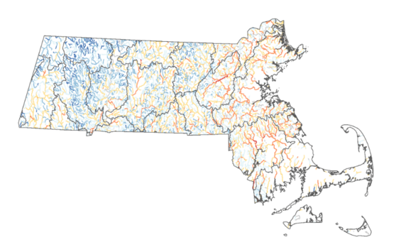
Figure 1. - Location of cold (blue), cool (orange) and warm (red) habitats during summer in rivers and streams by 2100.